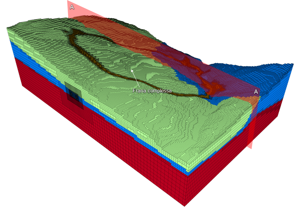
Analysis for studying the interaction between tunnel and large complex landslide
Three-dimensional numerical model with the objective of evaluating the evolution over time of the interaction between the tunnel and the large complex landslide present at the site through the use of the finite difference software FLAC3D and the advanced time-dependent constitutive law SHELVIP. it was possible to reconstruct the deformation history of the slope, calibrated on the evidence of the on-site monitoring, and to perform predictive analyses.
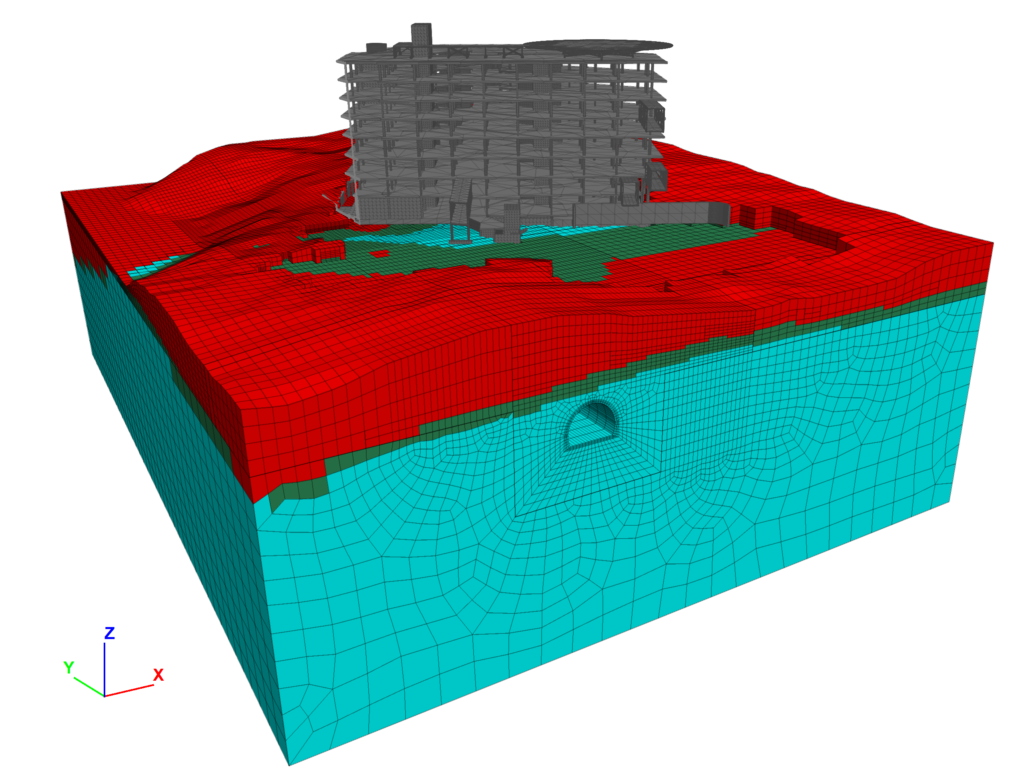
Interference between the construction of a hospital pavilion and tunnel
Development of numerical analyses to evaluate the effect of the construction of the works planned for the new Pavilion 0 of the Giannina Gaslini Institute in Genoa on the Lamba Doria double-track railway tunnel on the Genoa-Pisa line. Numerical analyses were developed with both a FEM model, using RS2 software, and an FDM model, using FLAC3D software. it was possible to reproduce the stress-state conditions of the subsurface around the tunnel in the current state and following the construction of the buildings. Client: Cooperativa Muratori e Braccianti di Carpi News: Analisi numeriche per lo studio interferenza fra la realizzazione di un nuovo padiglione ospedaliero e la galleria Lamba Doria
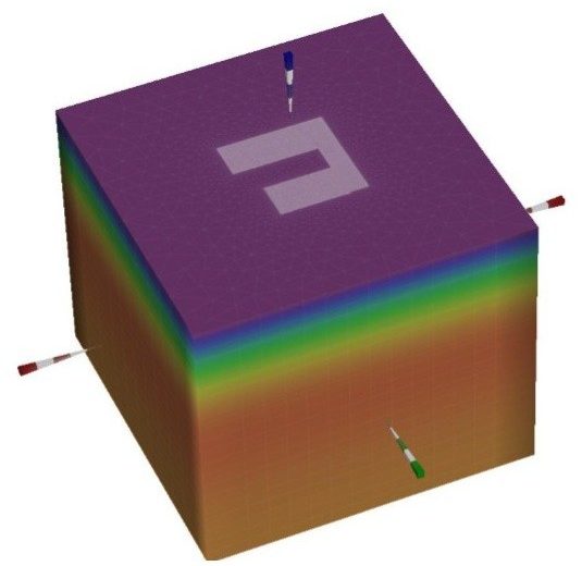
Analysis of the gravitational phenomenon of the eastern slope of Mt. Saresano
Analysis of the gravity phenomenon of the eastern slope of Mount Saresano with update of the DVR (Risk Assessment) of the plant located at the foot of the slope. Modelling of the instability initiation phase using advanced numerical models with hydraulic, seismic, gravitational and rheological forcings for the study of different instability scenarios and definition of pre-alert, alert and warning thresholds aimed at the safe management of the plant's activities.
Client: Italsacci SpA
Numerical modelling of the deposition of big bags at the Arzignano landfill
DEM numerical modeling under two-dimensional conditions to evaluate the optimization of FIBC waste depositing modes. The study was conducted through to the simulation of the mechanical behavior of the bag filling material, the behavior of single and grouped bags laid on a horizontal plane reproducing the modes adopted in the landfill and simulating the design configurations to reproduce bag stacking and stability assessment.
Client: Geotechnical Engineering srl
2D and 3D numerical modelling of Milano-Verona high speed railway tunnel
Construction of 2D numerical finite elements models using the RS2 as well as coupled thermo-mechanical finite differences models with FLAC software to support the executive design of the "Lonato" tunnel along Milano-Verona high-speed railway line. It consists of a single-track double-tube to be built using TMB-EPB for a lenght of 4.8 km. The aim of the modelling was ULS, SLEs verifications, the seismic analysis of the tunnels and the verification against fires of prefabricated concrete tunnel lining segments and the evaluation of the subsidence basin on the ground surface.
Client: Pini Swiss Engineers
Energy Geostructures
Techical support for thermal activation of the new HUB services in Trento
Technical support to the design for the thermal activation of the structural works of the new HUB of services under construction in the Ex-Zuffo area of Trento. It consists in the thermal activation of the foundation and the application of the GeothermSkin system to the walls against the ground. This building is part of the project ARV - Climate Positive Circular Communities and promoted in Italy by Polo di Innovazione Italiano.
Client: Dolomiti Energia SpA
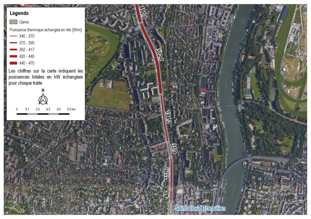
Preliminary study of the thermal activation of lines 15 West and 15 East in Paris
Prefeasibility study of geothermal activation of the 15 West and 15 East lines, part of the Grand Paris Express project, with the proposed activation of TBM sections through Enertun methodology and activation of buildings along the line (stations and shafts) through energy diaphragms. The results obtained demonstrated the possibility of exploiting geothermal energy for heating and cooling of buildings.
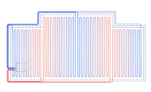
Project of the geothermal system of the Turin Metro Line 2
Design of the thermal activation of the new Line 2 of the Turin Metro. The activation included precast tunnel segmets, diaphragm walls. Numerical finite element models were created that could reproduce the geometrical, geological and geothermal characteristics of the system for each homogeneous zone. The support service was also provided for the preparation of detailed graphic drawings, the preparation of price analysis for the energy.
Client: Infratrasporti.TO Srl
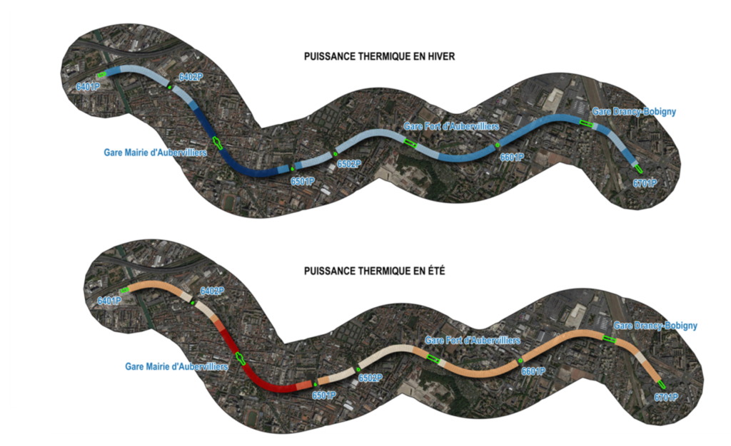
Preliminary study of the thermal activation of line 15 West tunnels GPE
Pre-feasibility study of the geothermal activation of the Line 15 West, part of the Grand Paris Express project. The thermal power that can be exchanged with the ground during winter and summer through the geothermal activation of the tunnel lining was calculated by using the simplified method developed by Di Donna and Barla (2016) and Insana and Barla (2020). The results obtained have demonstrated the possibility of using LN15O tunnels for heating and cooling purposes.
Geothermal activation of the Turin Metro line 2 feasibility study
Study of the geothermal potential deriving from the activation of the structural elements of the new Torino Metro Line 2. It was used a specific class parametrization methodology (5 parameters that describe the thermo-hydro-geological conditions of the Torino subsoil), developed by Geosolving, to divide into homogeneous sections. For each section a specific thermo-hydraulic finite elements numerical model has been realized.
Client: ATI Systra-Sotecni-Neosia-Italferr-AI Studio-AR Thème Associes-Studium
Feasibility study on the geothermal activation of a slab foundation
The activity was finalized to quantify in a preliminary way the thermal power obtainable through the geothermal activation of a slab foundation of a new building currently ongoing project. An advanced thermo-hydraulic finite elements model was adopted to reproduce the concrete foundation slab and the surrounding soil. The numerical results showed the feasibilty of the structures activation and a good amount of thermal power which can be extracted from the soil.
Client: Università degli Studi di Torino
Monitoring and EWS
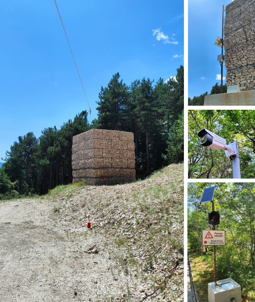
Monitoring and early warning system for avalanches in Lama dei Peligni (CH)
Design, implementation, and management of a monitoring and early warning system (EWS) for the control of avalanche phenomena generating and propagating along a valley upstream of the town of Lama dei Peligni, Abruzzo. It consists of a detection station equipped with clinometric sensors complemented by two traffic lights on the road and two high-resolution monitoring webcams.
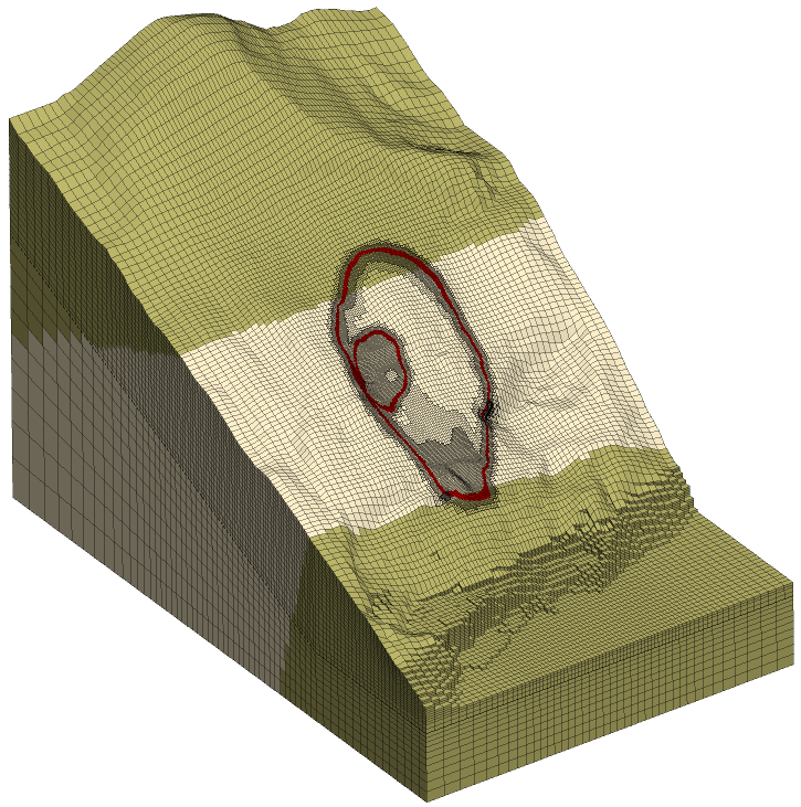
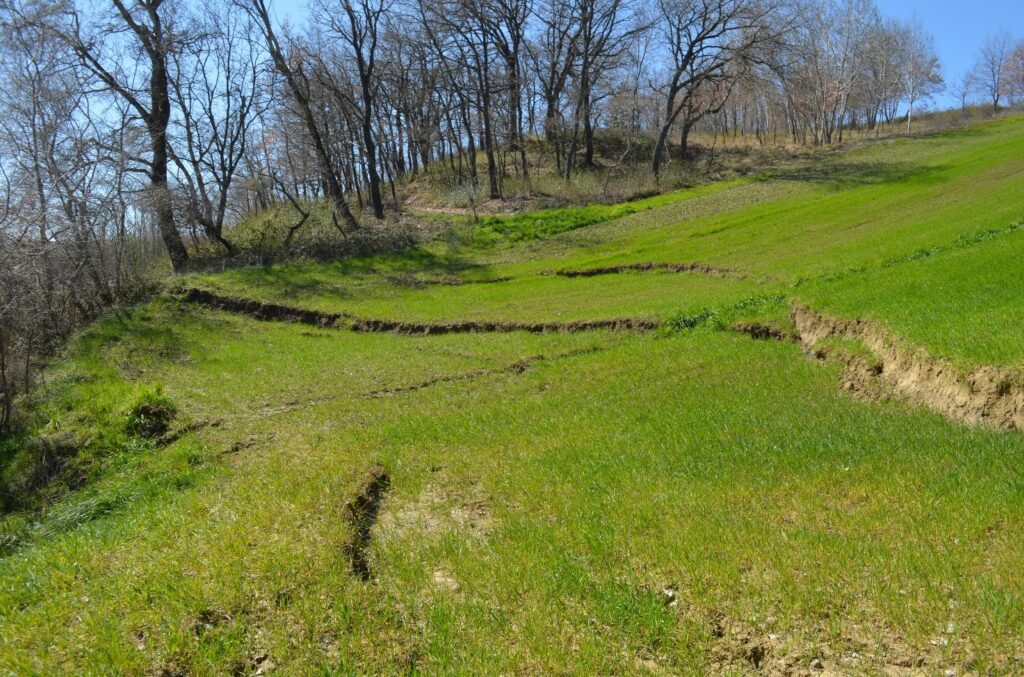
Analysis of landslide movement near the Scampitella tunnel
Technical assistance in the design of a monitoring system and the execution and interpretation of geological and geotechnical investigations of a landslide triggered in March 2021, in the sommital portion of the slope on the east portal, of the Scampitella tunnel along the A16 Highway.
Client: ASPI SpA
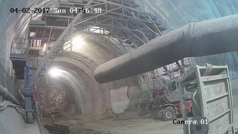
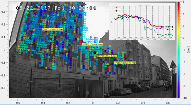
Ground-based radar monitoring of a tunnel excavation face
Advancement stages of a large diameter motorway tunnel monitored for over a week by a new generation ground-based SAR system (GBInSAR). The instrumentation, based on ArcSAR technology, allows to acquire images of the monitored scenario with a high accuracy in the displacements measurements. the technique was capable to obtain hundreds of displacement measurement points on tunnel face and to identify different sectors affected by deformations.
Buildings settlements monitoring during the construction of the Torino subway line 1 south extension
During the excavation of the metro line 1 southward extension (Lingotto-Bengasi), a new-concept of ground based radar instrument was used to monitor the deformation of buildings adjacent to the tunnel axis. The new monitoring tool consists of a radar head equipped with two antennas (transmitter and receiver) mounted on one meter long arm that is moving along an arc, thus creating a circular synthetic aperture. It is also equipped with a high resolution infrared optical camera and a laser scanner capable respectively of acquiring optical images and to obtain a digital elevation models (DEM) of the scenario to be used for the three-dimensional projection of the displacement maps.
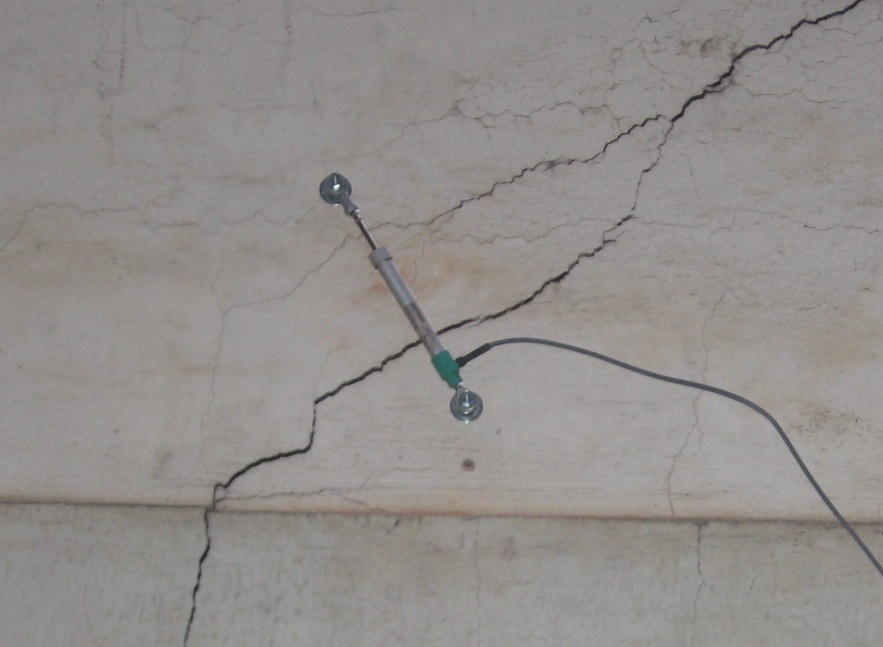
Cracks monitoring on a public building in Torino
A wireless monitoring network (WSN) consisting of 4 biaxial wall inclinometers and 4 inductive displacement transducers positioned across the main cracks was installed to keep under control the damage state of a public building. All the instruments are coupled with thermometric sensors to accurately detect temperature variations and to evaluate their influence on the monitored data. The data are collected at regular intervals and stored by a control unit equipped with a GSM module for transferring to a remote server accessible from the web.
Client: Università degli Studi di Torino
Environmental monitoring activities at the Campus Luigi Einaudi in Torino
Consulting service for the interpretation, analysis and critical evaluation of analytical results obtained from monitoring activities, as well as for the evaluation of soil vapor sampling results and comparison with the outside air of The University of Turin's Luigi Einaudi Campus (CLE). It was built on a portion of the former Italgas - Regina Margherita site, where for decades coal gas was produced for domestic and industrial use. The results were mapping and reconstruction of the time course of groundwater contaminant plumes and vapors and a risk analysis for approval by the relevant authorities.
Client: Università degli Studi di Torino
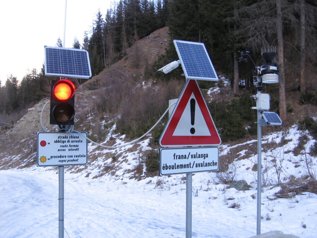
New monitoring and early warning system for avalanches and debris flows in Cogne (AO)
To protect a high-risk road located in the Cogne municipality (Aosta) from avalanches and debris flows, a new wireless monitoring and early waring system (EWS) was designed, assembled, installed and managed by Geosolving from 2017 to 2019. The system consists of a trigger line equipped with inclinometer sensors installed in the gully upstream of the road, two traffic lights located respectively upstream and downstream of the intersection of road and gully, two high-resolution cameras and a weather station. Whenever an avalanche or a debris flow occur, the sensors detect their passage along the gully and immediately the red traffic lights are turned on, thus interrupting traffic along the road. Client: Regione Autonoma della Valle d'Aosta
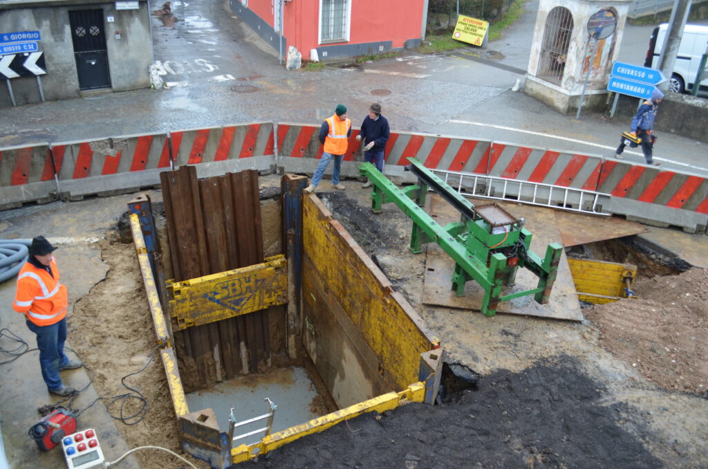
Buildings monitoring during pipe-jacking construction of new sewage system
To allow the safe construction of a new sewage system with the pipe-jacking technique in the vicinity of buildings in Foglizzo village (Torino), Geosolving has design, installed and managed a simple and inexpensive monitoring system. Four wall clinometers were installed on the external walls of the buildings closest to the excavation areas. By means of a wireless data transmission, it was possible to continuously monitor the potential effect of the excavations on the elements exposed to risk thus guaranteeing safety conditions for the workers and the resident.
Client: Sinergie srl
Stability analysis of a mixed stone-masonry wall
Monitoring system for safety reasons of the mixed stone masonry wall of the Darwin - Romero School Park in Rivoli (TO),adjacent to Strada del Pozzetto, using wire strain gauges installed on the inner face of the wall. The monitoring system allowed 4 sections of the wall to be monitored while at the same time establishing a set of displacement thresholds to mitigate the potential risk along the road. Finally, a numerical assessment of the stability of the wall was performed by creating a 2D numerical model using FLAC, determining the overall factor of safety of the soil-wall system, while an additional coupled thermo-mechanical analysis was used to understand the thermal effects due to seasonal variation in air temperature. Client: Città Metropolitana di Torino
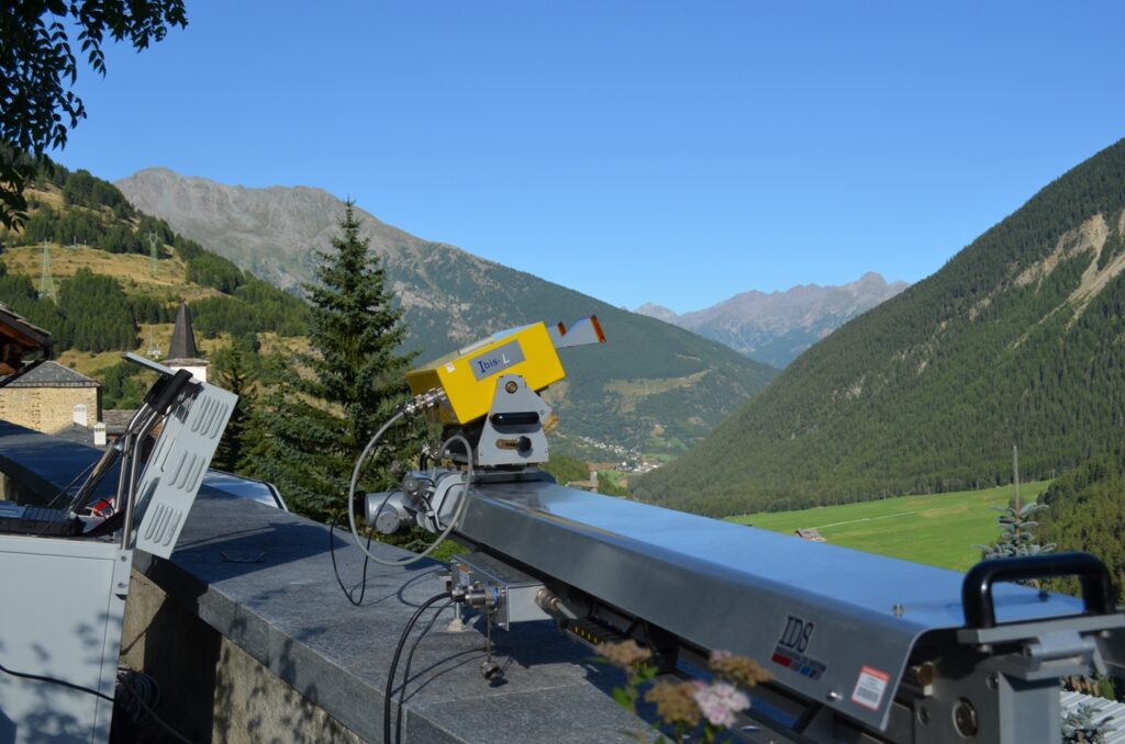
Comba Citrin landslide monitoring by ground-based radar interferometry
The ground-based radar interferometry (GBInSAR) technique was adopted to monitor the displacement of the Comba Citrin landslide, located in Valle d'Aosta, near the Italian-Swiss border. The landslide was reactivated during the 2000 flood event that severely damaged the entire Aosta Valley region. Using a measurement campaign with a discontinuous configuration, it was possible to follow the very slow seasonal displacements (a few mm) of the main landslide body, which are extremely difficult to measure with other in situ instrumentation. The cumulative displacement maps, obtained with a new advanced data processing technique, showed the presence of additional slope sectors affected by deformation outside the main body of the landslide. Client: Regione Autonoma Valle d'Aosta
Geothecnical and Environmental Engineering
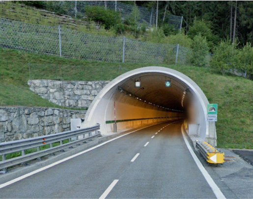
Application of the new Guidelines to the Valle D’Aosta highway Tunnels
Application of the method prescribed by the “Guidelines for Risk Classification and Management, Safety Assessment and Monitoring of Existing Tunnels” (LGG) of the Ministry of Infrastructure and Transport to determine the Attention Class to some tunnels belonging to the Aosta Valley Highway Network (RAV) and determination of the overall Attention Class of the tunnel.
Client: Raccordo Autostradale Valle d'Aosta SpA
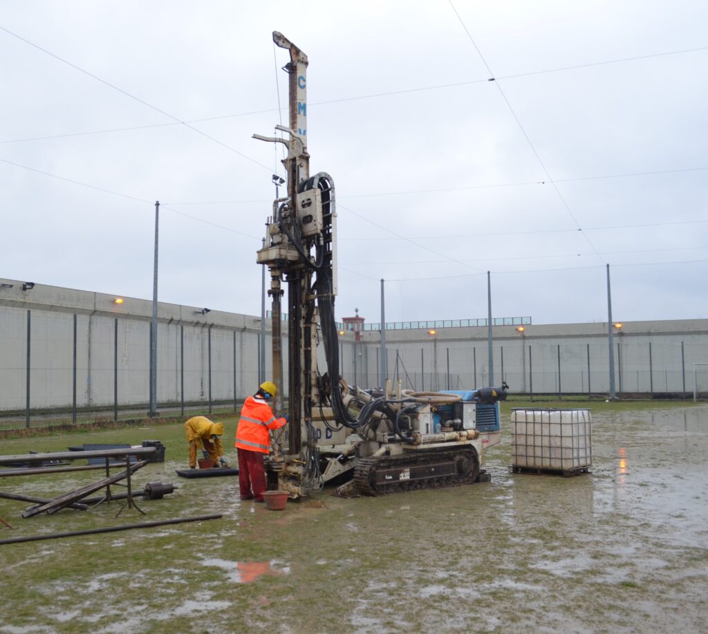
Compatibility studies, investigations, testing, geological and geotechnical characterization
The Department of the Penitentiary Administration has planned the construction of a detention hall with a capacity of n. 120 places at the Asti detention center, in the Quarto Inferiore area. Geosolving srl, in partnership with Sondeco srl, oversaw the drafting of the geological report and the investigations conducted, the hydraulic compatibility report and the verification of the purification capacity of the existing treatment waterplant, in addition to the data interpretation report for the geotechnical characterization of the site.
Client: Ministry of Justice, Department of Penitentiary Administration
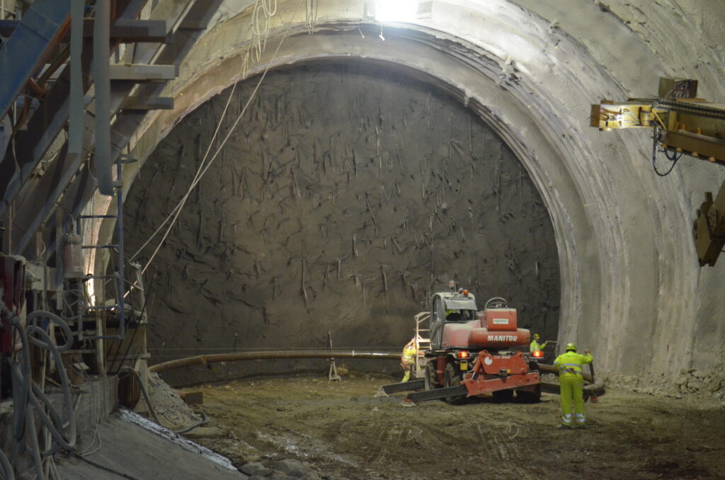
Study of the rock swelling behaviour along a railway tunnel
Starting from the re-analysis of laboratory tests including Huder & Amberg oedometric tests, traditional triaxial, swelling and creep tests, Geosolving has studied in detail the swelling behavior of a rock mass interested by the construction of an important railway tunnel in the southern Apennines. The data reanalysis was the starting point to define the swelling numerical parameters that were subsequently used in a set of finite differences numerical models. The result of the numerical analyses were used both for the design of the first phase support and for the final design of the tunnel lining.
Client: Ak Ingegneria Geotecnica Srl
Design of sewage and water distribution networks
Geosolving provided support to LS Ingegneria in the design of new sewage and water distribution networks aimed at rationalizing the water drainage in the Poirino Municipality (Torino). In particular, the project will include the construction of a new discharge conduit and a new lamination basin. Both these works will make it possible to avoid the saturation of the sewage system during intense rainfalls and the consequent flooding of some urbanized areas.At the same time, the replacement of some sections of the aqueduct was planned in order to increase the current quality standards while rationalizing the drinking water distribution network.
Client: Turin Metropolitan Water Authority
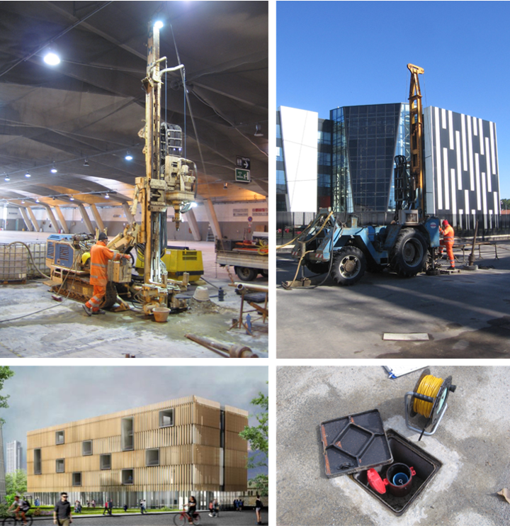
Geological, geotechnical and environmental investigations in the urban area of Turin
Geosolving and Sondeco assisted the Politecnico di Torino in planning and carrying out the geological, geotechnical and environmental in situ investigations for the tender design of new didactic and research structures in the Torino urban area. In detail, the activities were carried out on three different sites: new Learning Center located inside the Politecnico university campus, Pavilion V "Morandi" in the Torino Esposizioni complex, Digital Revolution House (DRH) located close to the Politecnico university campus. The aim of the investigations was to provide a complete picture of the geological, hydrogeological, geotechnical and environmental soil and groundwater conditions of the three different sites.
Client: Politecnico di Torino
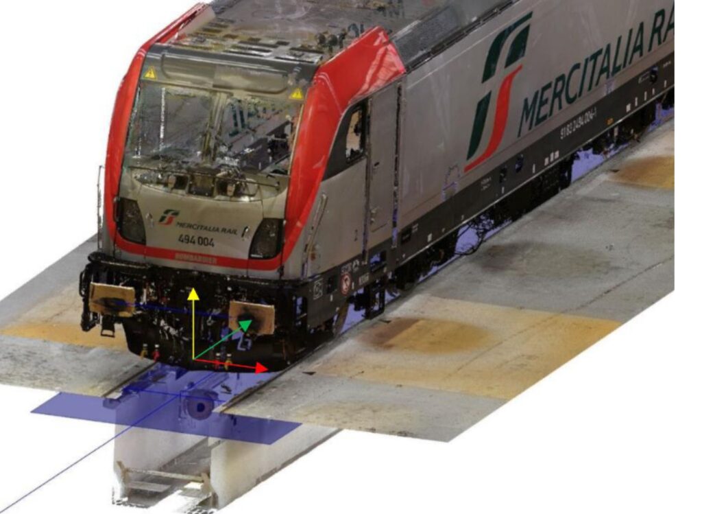
Dimensional control of a TRAXX DC3 train engine
Geosolving, in collaboration with La Mole 3D carried out laser scanner and laser tracker surveys aimed at the dimensional control of a TRAXX DC3 train engine. The measurements carried out in the Vado Ligure (SV) Bombardier plant in March 2019 have ensured high accuracy and precision according to the client requirements. The dimensional control was carried out by comparing the point cloud obtained from the laser scanner survey to the dimensional project features of the machine. The results of the activities excluded the presence of systematic defects of the train engine (rigid rotations or misalignments of the locomotive body), as well as potential systematic errors in the measure.