
Thanks to the Ground-Based Interferometric Synthetic Aperture Radar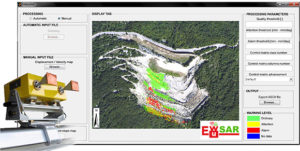 (GBInSAR) technology the displacement and velocity of the unstable slopes and the engineered excavation faces can be monitored continuously (24/7), near real time and over wide areas (3-4 km2), from distances up to 4 km and in complete safety conditions for the engaged operators. The GBInSAR technique allows to reach a measurement accuracy less than one mm regardless of the lighting (day and night) and the atmospheric condition (i.e. fog, rain, snow), without any target or benchmark on the monitored scenario.
The image in the upper right corner shows the GUI of the EWuSAR software, developed in collaboration with Politecnico di Torino, which can be used as an Early Warning System tool, thus integrating the GBInSAR monitoring capabilities.